
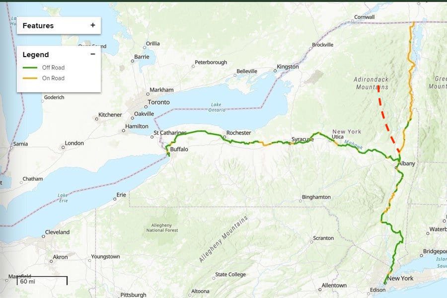
In 2020, Gov. Andrew Cuomo lauded the Empire State Trail, a 750-mile bike route from Manhattan to Albany and thence to either Buffalo or the Champlain Valley, depending on your objective.
Most of the Empire State Trail deserves praise, but the Adirondack section is a farce. For 123 miles, it follows Route 22, a state highway with a 55-mph speed limit and, all too often, narrow, crumbling shoulders.
My other complaint is that the trail ends at Rouses Point. Nothing against this picturesque village on Lake Champlain, but wouldn’t the majestic High Peaks be a more rewarding destination?
I suggest we create a bike route worthy of the Empire State imprimatur: a mostly off-road route from the tip of Manhattan to the edge of the High Peaks Wilderness. It would require a substantial public investment, but much of the physical infrastructure exists already.
Manhattan to Albany
The Empire State Trail begins at Battery Park in Manhattan and heads north along the Hudson River Greenway to Van Cortlandt Park in the Bronx and then leaves the city for the suburbs, small villages, woods and farmlands of the Hudson Valley. On the way to Albany, it crosses the mighty river three times. From the Big Apple to the state capital, the trail covers 200 miles. Three-quarters of it is off road.
Albany to Saratoga Springs
I recently got on the Empire State Trail in downtown Albany and biked north along the Hudson River. For the first 17 miles, I traveled largely off road, enjoying a variety of pleasing scenery: wetlands, meadows, woods and old canals. I crossed the Mohawk River three times near its confluence with the Hudson. I faced only two miles of on-road riding, mostly on quiet streets in the village of Green Island.
Outside the city of Mechanicville, I had to get on roads again and followed them four miles to the Zim Smith Trail (which is not part of the Empire State Trail). I biked this trail 11.5 miles to Ballston Spa. As of now, the Zim Smith Trail ends there, but plans exist to extend it north to Saratoga Spa State Park. Plans also call for extending it south to connect with the Empire State Trail. Once this work is done, cyclists will be able to ride roughly 40 miles from Albany to Saratoga Springs, with only a short on-road section.
Saratoga to the High Peaks
On the outskirts of Saratoga Springs is the start of an underused rail line that runs north for 90 miles to Tahawus, once a mining community, now the southern gateway to the High Peaks. For much of the way, it parallels the Hudson, crossing it once. Another section follows the Boreas River. For many miles, the corridor passes through forever-wild forest preserve. It ends at a former mine after crossing the Opalescent River.
If the rail corridor were turned into a recreational trail, cyclists would be able to bike largely off road from the state’s biggest city to its tallest mountains—a distance of roughly 330 miles.
You could camp along the way or stay in inns or B&Bs. When you reached Tahawus, you could park your bike and hike up Mount Marcy or one of the other High Peaks. For a shorter bike tour, you could start in Poughkeepsie, Albany or Saratoga Springs.
With the rest of this world-class bike route in place or in the offing, that leaves the rail corridor as the critical next step. The line has not been used for freight for decades. The only commercial users are relatively new: the Saratoga, Corinth & Hudson Railway, which runs a tourist train on seven miles of track, and Revolution Rail, which offers rail-bike rides of up to eight miles.
There are three owners of the corridor: the town of Corinth, Warren County and the state. Also, Revolution Rail owns a temporary easement on the northernmost 30 miles.
State and local officials have talked about turning the corridor into a multi-use recreational trail. It’s time to get serious and commission a study to chart a future for this valuable public asset. Rail trails elsewhere have proven to be an economic boon. There’s every reason to think this would be as well.
A safe bike route from the Big Apple to the High Peaks would attract countless riders and show off the best of the Empire State. It can happen, but only if Adirondack public officials and stakeholders get behind the idea.
This sounds like a cool idea, but isn’t the “rail” you describe something that private entity bought a few years ago? Or at least a section of it? There seems to be some information missing here? This doesn’t say anything about just and “easement”?
Times Union April 2022.
https://www.timesunion.com/business/article/Defunct-contested-Adironack-rail-line-gets-new-17131498.php
The ownership of the line from North Creek to Tahawus is complicated. The state is the owner, but there is an easement that has prevented the state from removing the tracks and creating a recreational trail. The easement has changed hands several times. A few years ago, Revolution Rail bought the easement with help from the Open Space Institute. OSI has an option to buy the easement if Revolution Rail cannot find commercial freight customers. If OSI buys the line, I think it would work with the state to create some kind of recreational corridor. I would hope the trail would accommodate road bikes–just as the new Adirondack Rail Trail does.
“there is an easement that has prevented the state from removing the tracks and creating a recreational trail”
Phil, this is a funny way to put it don’t you think. The state could have not sold them an easement if they wanted a trail?
Paul, the state did not sell them the easement. The federal government owned the easement when it created the rail line during WWII. It later sold the easement to National Lead. The easement has changed hands a few times since.
Got it – thanks. Did the state try to buy the easement?
I don’t think the state would have qualified as a buyer under the terms of the latest easement sale.
Thanks for writing a fantastic summary of what currently exists and what could be built/enhanced. I often use Route 22 by car during my wanderings. I’ve often wondered if a parallel bike trail, or at least an enhanced shoulder could be built. It’s such a beautiful road that takes in so much of New Yorks’ beauty and as well, our history.
There’s no question that a paved or gravel trail, built to parallel Rt 22 would be a wonderful alternative to the on-road sections of the Empire Trail north from Albany. Problem is, who pays for it. I think I read somewhere, 1 million per mile. When I Google map that distance it’s 200 miles or so. That’s a pretty big chink of money for a multi-use path. Not to mention the biggest problem is there is no corridor owned by the state on which to build, no defunct rail corridor. it’s all either on occasion public land, most likely all private, for which a land purchase would be required. This is why there has been no suggestion to install a dedicated path.
Good Luck ! I was a member of the board of AdkAction ( actually, all of AdkAction was on the board at that time. It was that small !) Lee Keet came up with this idea about a rait trail between Utica and Lake Placid. Dick Beamish, Publisher of the Adirondack Explorer at the time, jumped in with 2 feet and Hope Frenette from Tupper Lake and the head of the Snow Mobile Assoc. and others. Oh it was a jolly band ! Lo ! It was finished from Placid to Tupper in my lifetime ! Dick Beamish and I used to joke about that ! It was not only about money but community opposition and Permits and years of fits and starts. But s glorious result !
As an avid cyclist of 36 years, I understand the frustration of having a “trail” essentially just a bunch of signs on Rt 22. Reality is there is no defunct rail trail along the Albany to Rouses Point section to make into a multi use trail, that could be part of the Empire Trail. As well, I have mixed feelings about using the Saratoga to Tahawus rail as a bike trail. There is NOTHING along here that would attract families or more casual cyclists. The only people riding this would be hard core cyclists OK with the remoteness, It passes near North Creek, then is all wilderness rest of the way, until you hit Rt 28 and could detour into Newcomb. At least the Rt 22 route passes through towns, where you could get food and lodging. The reality is this Empire trail was thrown together by Cuomo and friends with little thought as the viability of parts of the route. They had the Erie Canal Trail as well as assorted sections sough of Kingston and then over to Brewster and down into the city, that are gems of bike trails. But north to Rouses was just gimmick.
Steve, thanks for the reply. You are right that there is no civilization between North Creek (or North River) and Newcomb, but some people may prefer biking through wilderness. Also, the distance from North Creek to Newcomb is only 30 miles or so. That’s an easy day for most touring cyclists, though perhaps not for everyone.
Rail Trail to Tahwus would be greatly improved if the state developed some primitive campsites along the way, including a cluster near the Blue Ridge road as a destination. In other words, create a reason to cycle to this spot. Right now there’s nothing although it’s a short 5 miles to the Lake Harris DEC campground. The state probably could improve cycle tourism in general by allowing the DEC campgrounds to accept walk in cycle tourists to show up and camp in a high density bicycle section of a campground with no advance reservations. This is done in a lot of places.
That seems like a good idea. If this rail trail became reality, I hope the state would develop amenities such as you suggest.
The Greenbrier River Trail in West Virginia has fantastic trailside campsites and relatively little development. It would be great model to follow. I love trains but I don’t see a future for this line despite the best efforts of past rail operators. Maybe they could do rails with trail for the seven mile southern section.
I’ve biked part of the Greenbrier. Great trail. Primitive campsites along the trail would be a nice amenity.
See an article in the Travel section of the Boston Sunday Globe for Nov. 10, 2024 by Diane Bair & Pamela West, “Don’t tell a soul, but this is the most gorgeous rail trail ever. (E-bikes, anyone)”. They recently bicycled on one of the two stretches of the new Adirondack Rail Trail now open, between Saranac Lake and Floodwood Road, the other being between Lake Placid and Saranac Lake.
My wife’s late mother grew up in the central Adirondacks, traveling by NYC trains between Saranac Lake & Tupper Lake while a schoolgirl. We’ve visited her relatives in Long Lake. I’ve never learned to ride a bike; the longest I’ve hiked in one day is 17 miles. I am a railfan and enjoyed earlier tourist trains between Saratoga Springs & North Creek; only a shorter part of that route has such trains now. Another outfit has them between Utica & Tupper Lake. I think when possible rail trails for non-motorized personal vehicles should co-exist with rail lines. And rail passenger service north of Saratoga Springs should be re-established ASAP, this time with much more speed than has been possible recently over CN’s tracks to and from Central Station in Montreal. The old route between Rouses Point on the D&H, its NJ subsidiary and CP’s Windsor Station in Montreal was much faster.
Warren County officials actually passed a resolution back in 2019 authorizing the County Administrator to move forward with the process of abandoning the County’s 40+ miles of the line. The rails-to-trails process with the Surface Transportation Board was stalled, but “abandonment” is still the official position of the County (as far as I know). Also, check out this website http://upperhudson.org/ with information on the envisioned Upper Hudson Rail Trail.
Claudia, I know Warren County has looked into this. My understanding is that the county cannot abandon the line (remove the tracks) until the North Creek-to-Tahawus section is abandoned. So far the Surface Transportation Board has blocked the state’s efforts to declare the line abandoned despite decades of disuse. I may get into this issue again in a later article.
>”I may get into this issue again in a later article.”
This would be a great article!
I love the idea of a trail from Saratoga to the High Peaks.
There are now reasonable bike trails from Manhattan to Lake George: Empire State Trail to Feeder Canal Trail to Warren County Bikeway. So I also think about Lake George to the High Peaks.
What can folks do to help make this a reality?
JP, you could email NYSDEC to express support for the rail trail.
public@dec.ny.gov
Would it be theoretically possible to make a loop trail departing North Creek to Newcomb with a return through Indian Lake?
One could envision a gravel/mountain bike trail segment returning from Newcomb via the Essex Chain, a new bridge over the Cedar River to the Chain of Lakes Road, then back down the big RT 28 hill to North Creek? That would be a world class adventure loop.
That hadn’t occurred to me, but it sounds like a great ride. DEC planned to build a new snowmobile bridge over the Cedar but never did. Environmentalists objected to the plan. There is an existing snowmobile trail that runs from the Newcomb to Indian Lake, but I don’t know how it is for biking.
Is there a AE article that encapsulates ALL the cycling trails within the blue line? (Especially the newer ones)Occasionally I see an interesting article but can never seem to find them when I need to.
What do you mean by cycling trail? The Adirondack Rail Trail is unique in the Adirondacks, but there plenty of mountain bike trails, dirt roads, old rail beds, etc. that people bike. There also is the Tobie Trail between Inlet and Old Forge.
I would also like to see the Bloomingdale Bog trail corridor resurfaced similar to the Adirondack Rail Trail to harden the sandy/muddy areas to better allow gravel bikes and wheelchairs. Perhaps turning that trail and side roads into a connected loop to the Rail Trail (via road) would enhance usage of both. I would be reluctant to widen it appreciebly in hopes of keeping a more “remote” sense when using it and keeping snowmobile speeds lower. Perhaps adding primitive “accessible” camping areas around Oregon Plains and/or Bigelow Road/bridge area could be considered.
Quiet. I don’t want too many people coming out and sharing that trail with me…
Too late…
https://www.adirondackexplorer.org/stories/bloomingdale-bog-outing-in-any-season
Boreas, I don’t believe that would be possible without an amendment to the Adirondack Park State Land Master Plan. In 2018, the APA amended the definition of Travel Corridor to accommodate the Adirondack Rail Trail. The APA news release at the time said the definition applies also to “future State-owned railroad corridors with existing rails.” The rail line to Tahawus fits the bill. The Bloomingdale Bog Trail does not.
Interesting, is this how they allow motorized e-bikes on the trail that is on FP land? I am surprised this didn’t require an amendment to article 14 to allow motors, other than snowmobiles, on these trails.
The Travel Corridor classification allows for uses not normally allowed in the Forest Preserve.
I am surprised (given the population over there) that a new electric train could not be a viable thing to bring people to that High Peaks trailhead. That would give it a direct connection to NYC. Like some of the ones you see in Swiss mountain towns and other parts of europe. Build a destination in Tahawus. That area is gorgeous.
If integrated with environmentally sensitive economic development for this area of the Adirondacks, it could be amazing!
OSI was not allowed to bid on the Tahawus line by themselves, because they had no railroad option. They teamed up with Revolution Rail behind the scenes, before the auction. I’m pretty sure that OSI’s eventual goal is to sell it to NYS and have it become a rail trail. There will probably have to be a few short places that have both tracks and trail, so Revolution Rail can still offer railbike rides. We cross country skied the route two winters ago, and it is fantastic. It is pretty remote as far as road crossings, but the Hudson and the Boreas are beautiful.
Fantastic idea! I love riding the trails around the North Country but it’s definitely treacherous on the roads around there.
You’ve given a really detailed and well thought out strategy. Now, which politician is going to accomplish something and sponsor this?
Thanks for the feedback. You asked the right question. It’s up to the public and other stakeholders to convince politicians that a rail trail is the way to go.
Wish I could ride the trail at my house to Syracuse then hit the main trail .